


RS-Marcilloles-Les Poipes

raymondfn
User
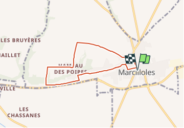

Length
6.8 km

Max alt
339 m

Uphill gradient
56 m
Km-Effort
7.6 km

Min alt
297 m

Downhill gradient
56 m
Boucle
Yes
Creation date :
2021-02-04 09:45:17.102
Updated on :
2023-03-01 14:16:01.41
1h42
Difficulty : Medium

FREE GPS app for hiking
 SityTrail
IGN / Geographical institutes
SityTrail Plus
The world is yours!
About
Trail Walking of 6.8 km to be discovered at Auvergne-Rhône-Alpes, Isère, Marcilloles. This trail is proposed by raymondfn.
Positioning
Country:
France
Region :
Auvergne-Rhône-Alpes
Department/Province :
Isère
Municipality :
Marcilloles
Location:
Unknown
Start:(Dec)
Start:(UTM)
671095 ; 5023077 (31T) N.
Comments