


vue sur ottrott

apa
User
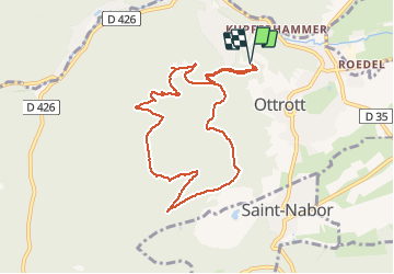

Length
8.7 km

Max alt
717 m

Uphill gradient
400 m
Km-Effort
14 km

Min alt
329 m

Downhill gradient
399 m
Boucle
Yes
Creation date :
2021-02-04 09:07:19.077
Updated on :
2021-02-04 12:25:36.271
2h34
Difficulty : Medium

FREE GPS app for hiking
 SityTrail
IGN / Geographical institutes
SityTrail Plus
The world is yours!
About
Trail Walking of 8.7 km to be discovered at Grand Est, Bas-Rhin, Ottrott. This trail is proposed by apa.
Description
Belle rando
Photos


Positioning
Country:
France
Region :
Grand Est
Department/Province :
Bas-Rhin
Municipality :
Ottrott
Location:
Unknown
Start:(Dec)
Start:(UTM)
383093 ; 5368775 (32U) N.
Comments