


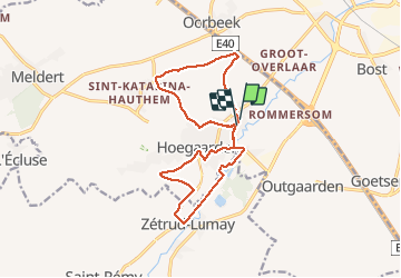
Boucle Hoegaerden

seghth
User

Length
14.1 km

Max alt
102 m

Uphill gradient
129 m
Km-Effort
15.8 km

Min alt
46 m

Downhill gradient
131 m
Boucle
Yes
Creation date :
2021-02-04 10:19:19.32
Updated on :
2021-02-04 13:56:52.333
2h30
Difficulty : Very easy

FREE GPS app for hiking
 SityTrail
IGN / Geographical institutes
SityTrail Plus
The world is yours!
About
Trail Walking of 14.1 km to be discovered at Flanders, Flemish Brabant, Hoegaarden. This trail is proposed by seghth.
Positioning
Country:
Belgium
Region :
Flanders
Department/Province :
Flemish Brabant
Municipality :
Hoegaarden
Location:
Hoegaarden
Start:(Dec)
Start:(UTM)
633941 ; 5627035 (31U) N.
Comments