


mallemort 84

aupi
User

Length
6.4 km

Max alt
309 m

Uphill gradient
137 m
Km-Effort
8.2 km

Min alt
207 m

Downhill gradient
138 m
Boucle
Yes
Creation date :
2021-02-04 13:04:33.786
Updated on :
2021-02-04 16:26:00.612
2h30
Difficulty : Easy

FREE GPS app for hiking
 SityTrail
IGN / Geographical institutes
SityTrail Plus
The world is yours!
About
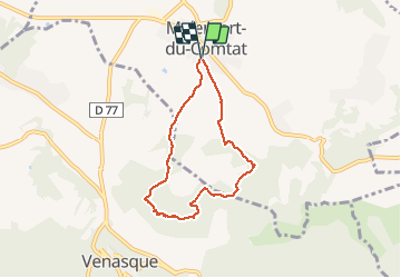
Trail Walking of 6.4 km to be discovered at Provence-Alpes-Côte d'Azur, Vaucluse, Malemort-du-Comtat. This trail is proposed by aupi.
Description
4 jolies bories belle vue sur Venasque
Photos


Positioning
Country:
France
Region :
Provence-Alpes-Côte d'Azur
Department/Province :
Vaucluse
Municipality :
Malemort-du-Comtat
Location:
Unknown
Start:(Dec)
Start:(UTM)
673058 ; 4876221 (31T) N.
Comments