


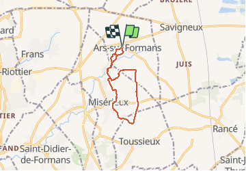
Ars sur Formans (9,8 km D. 135 m)

Thomasdanielle
User

Length
9.8 km

Max alt
266 m

Uphill gradient
135 m
Km-Effort
11.6 km

Min alt
224 m

Downhill gradient
133 m
Boucle
Yes
Creation date :
2021-02-05 12:33:04.0
Updated on :
2021-03-11 15:53:40.094
2h45
Difficulty : Easy

FREE GPS app for hiking
 SityTrail
IGN / Geographical institutes
SityTrail Plus
The world is yours!
About
Trail Walking of 9.8 km to be discovered at Auvergne-Rhône-Alpes, Ain, Ars-sur-Formans. This trail is proposed by Thomasdanielle.
Description
D/A parking le long de la rue des Muriers ou parking centre du village
Positioning
Country:
France
Region :
Auvergne-Rhône-Alpes
Department/Province :
Ain
Municipality :
Ars-sur-Formans
Location:
Unknown
Start:(Dec)
Start:(UTM)
640837 ; 5094949 (31T) N.
Comments