


BLANZAT - COL DU BANCILLON

walrou63
User
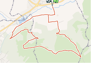

Length
7.2 km

Max alt
556 m

Uphill gradient
190 m
Km-Effort
9.7 km

Min alt
373 m

Downhill gradient
190 m
Boucle
Yes
Creation date :
2021-02-05 17:42:21.595
Updated on :
2021-02-05 17:45:11.114
2h10
Difficulty : Easy

FREE GPS app for hiking
 SityTrail
IGN / Geographical institutes
SityTrail Plus
The world is yours!
About
Trail On foot of 7.2 km to be discovered at Auvergne-Rhône-Alpes, Puy-de-Dôme, Blanzat. This trail is proposed by walrou63.
Description
Petite boucle près de Blanzat, malgré des chemins boueux en ce début février.
Positioning
Country:
France
Region :
Auvergne-Rhône-Alpes
Department/Province :
Puy-de-Dôme
Municipality :
Blanzat
Location:
Unknown
Start:(Dec)
Start:(UTM)
506000 ; 5074523 (31T) N.
Comments