


2014-05-13-Linas 70km

Lucquiaud
User
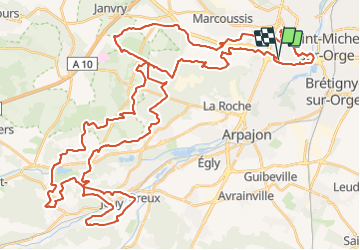

Length
72 km

Max alt
171 m

Uphill gradient
1062 m
Km-Effort
86 km

Min alt
40 m

Downhill gradient
1062 m
Boucle
Yes
Creation date :
2018-09-15 15:06:45.216
Updated on :
2018-09-15 15:06:45.298
4h41
Difficulty : Difficult

FREE GPS app for hiking
 SityTrail
IGN / Geographical institutes
SityTrail Plus
The world is yours!
About
Trail Mountain bike of 72 km to be discovered at Ile-de-France, Essonne, Linas. This trail is proposed by Lucquiaud.
Positioning
Country:
France
Region :
Ile-de-France
Department/Province :
Essonne
Municipality :
Linas
Location:
Unknown
Start:(Dec)
Start:(UTM)
446160 ; 5385933 (31U) N.
Comments
Parcours complet et tres sympa attention c est long