


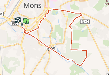
Mont panisel via sentier cavenaile

laurentgyn
User

Length
9.4 km

Max alt
113 m

Uphill gradient
132 m
Km-Effort
11.1 km

Min alt
28 m

Downhill gradient
132 m
Boucle
Yes
Creation date :
2021-02-06 09:12:32.0
Updated on :
2021-02-06 11:52:19.118
2h33
Difficulty : Easy

FREE GPS app for hiking
 SityTrail
IGN / Geographical institutes
SityTrail Plus
The world is yours!
About
Trail Walking of 9.4 km to be discovered at Wallonia, Hainaut, Mons. This trail is proposed by laurentgyn.
Description
Le mont panisel autrement au départ de Mons centre .
Le début de la chaussee de binche est bruyant mais après c’est bucolique.
Positioning
Country:
Belgium
Region :
Wallonia
Department/Province :
Hainaut
Municipality :
Mons
Location:
Mons
Start:(Dec)
Start:(UTM)
567177 ; 5588725 (31U) N.
Comments