


sortie AU5V

gilbertdu60
User

Length
30 km

Max alt
99 m

Uphill gradient
304 m
Km-Effort
34 km

Min alt
25 m

Downhill gradient
242 m
Boucle
No
Creation date :
2014-12-10 00:00:00.0
Updated on :
2014-12-10 00:00:00.0
4h29
Difficulty : Medium

FREE GPS app for hiking
 SityTrail
IGN / Geographical institutes
SityTrail Plus
The world is yours!
About
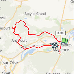
Trail Cycle of 30 km to be discovered at Hauts-de-France, Oise, Pont-Sainte-Maxence. This trail is proposed by gilbertdu60.
Description
circuit autour des marais de rosoy et verderonne départ de pont été maxence
Positioning
Country:
France
Region :
Hauts-de-France
Department/Province :
Oise
Municipality :
Pont-Sainte-Maxence
Location:
Unknown
Start:(Dec)
Start:(UTM)
471250 ; 5461044 (31U) N.
Comments