


montherme.liry.2021.02.07

trusgnachjf
User
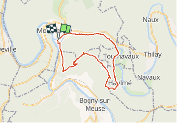

Length
13.8 km

Max alt
404 m

Uphill gradient
386 m
Km-Effort
19 km

Min alt
137 m

Downhill gradient
385 m
Boucle
Yes
Creation date :
2021-02-07 12:48:27.079
Updated on :
2021-02-07 16:17:13.337
3h27
Difficulty : Very easy

FREE GPS app for hiking
 SityTrail
IGN / Geographical institutes
SityTrail Plus
The world is yours!
About
Trail Walking of 13.8 km to be discovered at Grand Est, Ardennes, Monthermé. This trail is proposed by trusgnachjf.
Positioning
Country:
France
Region :
Grand Est
Department/Province :
Ardennes
Municipality :
Monthermé
Location:
Unknown
Start:(Dec)
Start:(UTM)
625177 ; 5526744 (31U) N.
Comments