


Soum d' Ostès 2020-03-08 001

mitch1952
User
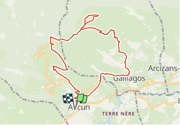

Length
11.9 km

Max alt
1453 m

Uphill gradient
702 m
Km-Effort
21 km

Min alt
872 m

Downhill gradient
702 m
Boucle
Yes
Creation date :
2021-02-08 13:20:14.645
Updated on :
2022-06-07 13:34:07.955
4h50
Difficulty : Very difficult

FREE GPS app for hiking
 SityTrail
IGN / Geographical institutes
SityTrail Plus
The world is yours!
About
Trail Walking of 11.9 km to be discovered at Occitania, Hautespyrenees, Aucun. This trail is proposed by mitch1952.
Positioning
Country:
France
Region :
Occitania
Department/Province :
Hautespyrenees
Municipality :
Aucun
Location:
Unknown
Start:(Dec)
Start:(UTM)
728736 ; 4761635 (30T) N.
Comments