Trail Walking Saint-Raphaël - Les suvières via le pic de l'ours depuis ND - Photo

Les suvières via le pic de l'ours depuis ND

 ETMU5496
ETMU5496

User

© OpenStreetMap contributors
Length
Length
22 km
Max alt
Max alt
538 m
Uphill gradient
Uphill gradient
1049 m
Km-Effort
Km-Effort  
36 km
Min alt
Min alt
76 m
Downhill gradient
Downhill gradient
1045 m
Boucle
Boucle
Yes
Creation date :
2021-02-09 07:55:44.0
Updated on :
2021-02-11 18:07:27.507

(0 Reviews)

Walking
Walking
5h30
Difficulty : Difficult

Scan this QR Code to open this trail in the SityTrail application

FREE GPS app for hiking

Logo SityTrail SityTrail

IGN / Geographical institutes

Download SityTrail from the App Store Download SityTrail from Google Play

Logo SityTrail SityTrail World

The world is yours!

Download SityTrail from the App Store Download SityTrail from Google Play Download SityTrail on Huawei AppGallery

About

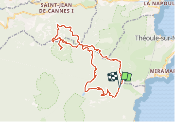
Trail Walking of 22 km to be discovered at Provence-Alpes-Côte d'Azur, Var, Saint-Raphaël. This trail is proposed by ETMU5496.

Description

départ col Notre Dame
ascension du pic de l'Ours direct
descente du ravin de la dent de l'Ours
ascension jusqu'au col des 3 termes
tour du Marsaou et ascension des Suvières
descente au col des 3 termes
ascension vers le Mont Pelet
descente au col de la Cadière
traversée des Grues
arrivée col Notre Dame

Elevation profile

Photos

Positioning

Country:
France
Region :
Provence-Alpes-Côte d'Azur
Department/Province :
Var
Municipality :
Saint-Raphaël
Location:
Unknown
Start:(UTM)
331110 ; 4816305 (32T) N.

Trails nearby

Trail Walking Saint-Raphaël - Massif d'ésterel-grande boucle pic cap roux - Photo
Walking
jeromelacoste

Walking

Medium
(2)
Saint-Raphaël, Provence-Alpes-Côte d'Azur, Var, France
10.4 km | 17.5 km-effort
2h 58min
Yes
Trail Walking Saint-Raphaël - Le tour du Pic du Cap Roux - St Raphaël (Agay) - Photo
Walking
tracegps

Walking

Medium
(2)
Saint-Raphaël, Provence-Alpes-Côte d'Azur, Var, France
7.2 km | 12.8 km-effort
2h 0min
Yes
Trail Walking Saint-Raphaël - Pic du Cap Roux - Photo
Walking
Kilroy06

Walking

Very easy
(4)
Saint-Raphaël, Provence-Alpes-Côte d'Azur, Var, France
4.1 km | 7.8 km-effort
1h 17min
Yes
Trail Walking Mandelieu-la-Napoule - Mont Saint Martin - Photo
Walking
Kilroy06

Walking

Easy
(1)
Mandelieu-la-Napoule, Provence-Alpes-Côte d'Azur, Maritime Alps, France
9 km | 14.2 km-effort
3h 0min
Yes
Trail Walking Saint-Raphaël - Agay - Sainte-Barbe - Étang des Nénuphares - Photo
Walking
E.BURCK

Walking

Easy
(2)
Saint-Raphaël, Provence-Alpes-Côte d'Azur, Var, France
5 km | 6.2 km-effort
2h 8min
Yes
Trail Walking Saint-Raphaël - Tour du Pic de l'Ours - Le Trayas - Photo
Walking
tracegps

Walking

Medium
(1)
Saint-Raphaël, Provence-Alpes-Côte d'Azur, Var, France
9.5 km | 16 km-effort
3h 0min
Yes
Trail Walking Saint-Raphaël - Circuit Esterel Rocher St Barthelemy, Chapelle et Cap Roux - Photo
Walking
GrouGary

Walking

Very easy
(1)
Saint-Raphaël, Provence-Alpes-Côte d'Azur, Var, France
11.4 km | 19.8 km-effort
3h 51min
Yes
Trail Walking Saint-Raphaël - 2020-12-01_16h14m20_cf774ce6158282e0995be918291d16985b71c850 - Photo
Walking
LtZIP

Walking

Easy
(1)
Saint-Raphaël, Provence-Alpes-Côte d'Azur, Var, France
11.5 km | 16.1 km-effort
3h 0min
Yes
Trail On foot Théoule-sur-Mer - Tracé Rocher des Monges par col de Théoule - Photo
On foot
Sylvie Cagnes

On foot

Very easy
(1)
Théoule-sur-Mer, Provence-Alpes-Côte d'Azur, Maritime Alps, France
7.2 km | 11.2 km-effort
Unknown
Yes


Close
My subscriptions