


2021-02-10_21h42m24_Mont Mounier 15-SEP-19

GrouGary
User
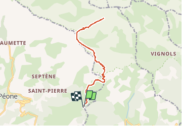

Length
16.9 km

Max alt
2791 m

Uphill gradient
1137 m
Km-Effort
32 km

Min alt
1745 m

Downhill gradient
1145 m
Boucle
Yes
Creation date :
2021-02-10 20:42:24.995
Updated on :
2025-07-07 16:15:19.783
7h17
Difficulty : Medium

FREE GPS app for hiking
 SityTrail
IGN / Geographical institutes
SityTrail Plus
The world is yours!
About
Trail Walking of 16.9 km to be discovered at Provence-Alpes-Côte d'Azur, Maritime Alps, Péone. This trail is proposed by GrouGary.
Positioning
Country:
France
Region :
Provence-Alpes-Côte d'Azur
Department/Province :
Maritime Alps
Municipality :
Péone
Location:
Unknown
Start:(Dec)
Start:(UTM)
336615 ; 4886259 (32T) N.
Comments