


col rati

Louna
User
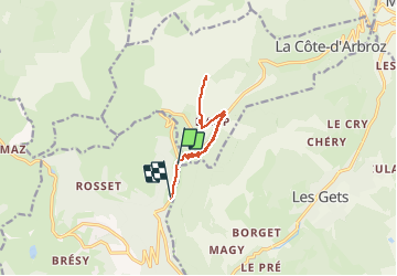

Length
9.3 km

Max alt
1638 m

Uphill gradient
439 m
Km-Effort
15.2 km

Min alt
1187 m

Downhill gradient
459 m
Boucle
No
Creation date :
2021-02-11 08:57:03.608
Updated on :
2021-02-11 16:54:08.673
4h45
Difficulty : Very easy

FREE GPS app for hiking
 SityTrail
IGN / Geographical institutes
SityTrail Plus
The world is yours!
About
Trail Snowshoes of 9.3 km to be discovered at Auvergne-Rhône-Alpes, Upper Savoy, Taninges. This trail is proposed by Louna .
Positioning
Country:
France
Region :
Auvergne-Rhône-Alpes
Department/Province :
Upper Savoy
Municipality :
Taninges
Location:
Unknown
Start:(Dec)
Start:(UTM)
316157 ; 5114811 (32T) N.
Comments