


Les cols de Couraduque,de la serre , du Berbeillet , de Bazès

mitch1952
User
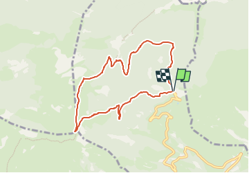

Length
8.2 km

Max alt
1613 m

Uphill gradient
342 m
Km-Effort
12.8 km

Min alt
1289 m

Downhill gradient
341 m
Boucle
Yes
Creation date :
2021-02-11 17:29:32.052
Updated on :
2022-06-07 14:05:35.712
3h20
Difficulty : Medium

FREE GPS app for hiking
 SityTrail
IGN / Geographical institutes
SityTrail Plus
The world is yours!
About
Trail On foot of 8.2 km to be discovered at Occitania, Hautespyrenees, Aucun. This trail is proposed by mitch1952.
Positioning
Country:
France
Region :
Occitania
Department/Province :
Hautespyrenees
Municipality :
Aucun
Location:
Unknown
Start:(Dec)
Start:(UTM)
728011 ; 4763644 (30T) N.
Comments