


La pellée

sameja
User
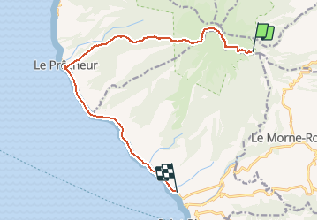

Length
18.2 km

Max alt
1245 m

Uphill gradient
592 m
Km-Effort
29 km

Min alt
0 m

Downhill gradient
1391 m
Boucle
No
Creation date :
2021-02-11 14:26:08.0
Updated on :
2021-02-11 19:50:40.917
5h23
Difficulty : Difficult

FREE GPS app for hiking
 SityTrail
IGN / Geographical institutes
SityTrail Plus
The world is yours!
About
Trail Nordic walking of 18.2 km to be discovered at Martinique, Unknown, L'Ajoupa-Bouillon. This trail is proposed by sameja.
Description
La boucle
Photos


21 photos in total. Please click on a photo to see them all in the gallery.
Positioning
Country:
France
Region :
Martinique
Department/Province :
Unknown
Municipality :
L'Ajoupa-Bouillon
Location:
Unknown
Start:(Dec)
Start:(UTM)
698966 ; 1637724 (20P) N.
Comments