


Cournols_Olloix_St_Saturnin

jagarnier
User GUIDE
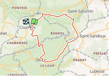

Length
16.6 km

Max alt
855 m

Uphill gradient
485 m
Km-Effort
23 km

Min alt
513 m

Downhill gradient
480 m
Boucle
Yes
Creation date :
2021-02-12 15:24:44.849
Updated on :
2023-11-29 09:00:04.183
5h00
Difficulty : Difficult

FREE GPS app for hiking
 SityTrail
IGN / Geographical institutes
SityTrail Plus
The world is yours!
About
Trail Walking of 16.6 km to be discovered at Auvergne-Rhône-Alpes, Puy-de-Dôme, Cournols. This trail is proposed by jagarnier.
Photos

Positioning
Country:
France
Region :
Auvergne-Rhône-Alpes
Department/Province :
Puy-de-Dôme
Municipality :
Cournols
Location:
Unknown
Start:(Dec)
Start:(UTM)
502763 ; 5054731 (31T) N.
Comments
itinéraire à revoir, 2 sections hors de tout chemin