


SityTrail - le gardot fait le 11/2/2021

gerardmicheline
User
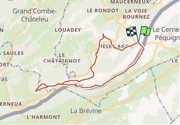

Length
16.3 km

Max alt
1289 m

Uphill gradient
468 m
Km-Effort
23 km

Min alt
1069 m

Downhill gradient
468 m
Boucle
Yes
Creation date :
2021-02-12 16:04:11.322
Updated on :
2021-02-12 16:04:11.322

FREE GPS app for hiking
 SityTrail
IGN / Geographical institutes
SityTrail Plus
The world is yours!
About
Trail of 16.3 km to be discovered at Bourgogne-Franche-Comté, Doubs, Montlebon. This trail is proposed by gerardmicheline.
Positioning
Country:
France
Region :
Bourgogne-Franche-Comté
Department/Province :
Doubs
Municipality :
Montlebon
Location:
Unknown
Start:(Dec)
Start:(UTM)
320885 ; 5209222 (32T) N.
Comments