


sortie vtt du 14022021

fabwin
User GUIDE
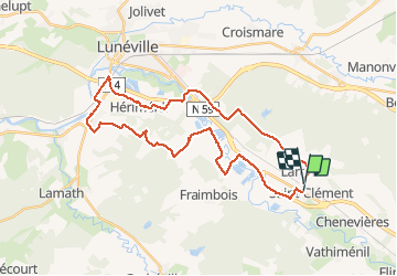

Length
32 km

Max alt
264 m

Uphill gradient
241 m
Km-Effort
36 km

Min alt
216 m

Downhill gradient
238 m
Boucle
No
Creation date :
2021-02-14 08:01:46.56
Updated on :
2021-02-14 11:19:10.599
2h37
Difficulty : Medium

FREE GPS app for hiking
 SityTrail
IGN / Geographical institutes
SityTrail Plus
The world is yours!
About
Trail Mountain bike of 32 km to be discovered at Grand Est, Meurthe-et-Moselle, Saint-Clément. This trail is proposed by fabwin.
Positioning
Country:
France
Region :
Grand Est
Department/Province :
Meurthe-et-Moselle
Municipality :
Saint-Clément
Location:
Unknown
Start:(Dec)
Start:(UTM)
322968 ; 5378211 (32U) N.
Comments