


Tour de margny

lahoche
User
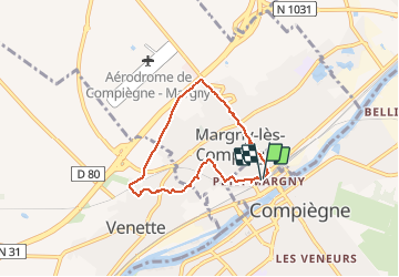

Length
5.3 km

Max alt
85 m

Uphill gradient
63 m
Km-Effort
6.1 km

Min alt
30 m

Downhill gradient
63 m
Boucle
Yes
Creation date :
2021-02-14 12:30:56.0
Updated on :
2021-02-14 14:00:57.851
1h25
Difficulty : Easy

FREE GPS app for hiking
 SityTrail
IGN / Geographical institutes
SityTrail Plus
The world is yours!
About
Trail Walking of 5.3 km to be discovered at Hauts-de-France, Oise, Compiègne. This trail is proposed by lahoche.
Description
Promenade facile et vue sur Compiegne
Positioning
Country:
France
Region :
Hauts-de-France
Department/Province :
Oise
Municipality :
Compiègne
Location:
Unknown
Start:(Dec)
Start:(UTM)
486990 ; 5474292 (31U) N.
Comments