


Cerdon

GioA10
User
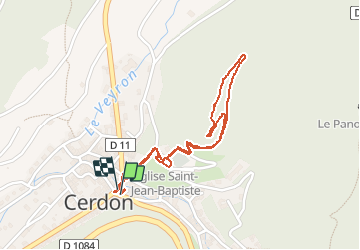

Length
2.1 km

Max alt
428 m

Uphill gradient
104 m
Km-Effort
3.5 km

Min alt
320 m

Downhill gradient
105 m
Boucle
Yes
Creation date :
2021-02-14 13:41:20.0
Updated on :
2021-02-14 14:34:51.754
52m
Difficulty : Unknown

FREE GPS app for hiking
 SityTrail
IGN / Geographical institutes
SityTrail Plus
The world is yours!
About
Trail Walking of 2.1 km to be discovered at Auvergne-Rhône-Alpes, Ain, Cerdon. This trail is proposed by GioA10.
Positioning
Country:
France
Region :
Auvergne-Rhône-Alpes
Department/Province :
Ain
Municipality :
Cerdon
Location:
Unknown
Start:(Dec)
Start:(UTM)
690636 ; 5105941 (31T) N.
Comments