![](/images/other/stat-length.png)
![Trail Mountain bike Bondoufle - rando dimanche bondoufle-etrechy - Photo](https://media.geolcdn.com/t/1900/400/ext.pjpeg?maxdim=2&url=https%3A%2F%2Fstatic1.geolcdn.com%2Fsiteimages%2Fupload%2Ffiles%2F1524743154velo.jpg)
rando dimanche bondoufle-etrechy
marsupio
User
![Length](/images/other/stat-length.png)
Length
66 km
![Max alt](https://static1.geolcdn.com/siteimages/upload/files/1508320355ic_sort_altitude_max_24dp.png)
Max alt
164 m
![Uphill gradient](https://static1.geolcdn.com/siteimages/upload/files/1508320355ic_sort_den_pos_24dp.png)
Uphill gradient
765 m
![Km-Effort](/images/other/stat-length.png)
Km-Effort
76 km
![Min alt](https://static1.geolcdn.com/siteimages/upload/files/1508320355ic_sort_altitude_min_24dp.png)
Min alt
64 m
![Downhill gradient](https://static1.geolcdn.com/siteimages/upload/files/1508320355ic_sort_den_neg_24dp.png)
Downhill gradient
768 m
![Boucle](https://static1.geolcdn.com/siteimages/upload/files/16400158638029165_repeat_loop_refresh_sync_direction_icon.png)
Boucle
No
Creation date :
2021-02-14 07:37:12.131
Updated on :
2021-02-14 18:15:20.66
![Mountain bike](https://static1.geolcdn.com/sitytour/trail-icons/202.png)
6h26
Difficulty : Difficult
![Scan this QR Code to open this trail in the SityTrail application](https://capi.geolives.com/qq0zvz2zws4bq2lad0pu/sitytour/trails/2671153/qr.png?size=200)
FREE GPS app for hiking
About
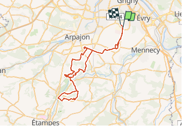
Trail Mountain bike of 66 km to be discovered at Ile-de-France, Essonne, Bondoufle. This trail is proposed by marsupio.
Description
Départ temperature -6°, ça caille !
Roulage difficile alternant chemins verglacés ou/et enneigés.
Un peu de vent, le soleil était de la partie.
Positioning
Country:
France
Region :
Ile-de-France
Department/Province :
Essonne
Municipality :
Bondoufle
Location:
Unknown
Start:(Dec)
Start:(UTM)
453766 ; 5383876 (31U) N.
Comments
Trails nearby
![Trail Walking Écharcon - Autour de Vert le Petit - Photo](https://media.geolcdn.com/t/375/260/ext.jpg?maxdim=2&url=https%3A%2F%2Fservices.sitytrail.com%2FGeolivesWS%2FDownloadMedia.ashx%3FTrailID%3D102739%26Media%3D3871_4.jpg)
![Walking Walking](https://static1.geolcdn.com/sitytour/trail-icons/101.png)
Autour de Vert le Petit
Walking
Medium
(1)
Écharcon,
Ile-de-France,
Essonne,
France
![](/images/other/stat-length.png)
16 km | 17.9 km-effort
4h 0min
![](https://static1.geolcdn.com/siteimages/upload/files/16400158638029165_repeat_loop_refresh_sync_direction_icon.png)
Yes
![Trail On foot Mennecy - Les Etangs de Mennecy - Photo](https://media.geolcdn.com/t/375/260/ext.jpg?maxdim=2&url=https%3A%2F%2Fstatic1.geolcdn.com%2Fsiteimages%2Fupload%2Ffiles%2F1545311037marcheuse_200dpi.jpg)
![On foot On foot](https://static1.geolcdn.com/sitytour/trail-icons/100.png)
Les Etangs de Mennecy
On foot
Difficult
(1)
Mennecy,
Ile-de-France,
Essonne,
France
![](/images/other/stat-length.png)
18.5 km | 21 km-effort
4h 3min
![](https://static1.geolcdn.com/siteimages/upload/files/16400158638029165_repeat_loop_refresh_sync_direction_icon.png)
Yes
![Trail Mountain bike Bondoufle - rando](https://media.geolcdn.com/t/375/260/ext.jpg?maxdim=2&url=https%3A%2F%2Fstatic1.geolcdn.com%2Fsiteimages%2Fupload%2Ffiles%2F1524743154velo.jpg)
![Mountain bike Mountain bike](https://static1.geolcdn.com/sitytour/trail-icons/202.png)
rando "sec" dimanche 07/02/2021
Mountain bike
Easy
(1)
Bondoufle,
Ile-de-France,
Essonne,
France
![](/images/other/stat-length.png)
56 km | 63 km-effort
8min
![](https://static1.geolcdn.com/siteimages/upload/files/16400158638029165_repeat_loop_refresh_sync_direction_icon.png)
Yes
![Trail Mountain bike Bondoufle - Senart - Photo](https://media.geolcdn.com/t/375/260/ext.jpg?maxdim=2&url=https%3A%2F%2Fstatic1.geolcdn.com%2Fsiteimages%2Fupload%2Ffiles%2F1524743154velo.jpg)
![Mountain bike Mountain bike](https://static1.geolcdn.com/sitytour/trail-icons/202.png)
Senart
Mountain bike
Very difficult
(1)
Bondoufle,
Ile-de-France,
Essonne,
France
![](/images/other/stat-length.png)
46 km | 52 km-effort
3h 30min
![](https://static1.geolcdn.com/siteimages/upload/files/16400158638029165_repeat_loop_refresh_sync_direction_icon.png)
Yes
![Trail Mountain bike Bondoufle - Sortie club du 29/09/2019 - Photo](https://media.geolcdn.com/t/375/260/ext.jpg?maxdim=2&url=https%3A%2F%2Fstatic1.geolcdn.com%2Fsiteimages%2Fupload%2Ffiles%2F1524743154velo.jpg)
![Mountain bike Mountain bike](https://static1.geolcdn.com/sitytour/trail-icons/202.png)
Sortie club du 29/09/2019
Mountain bike
Difficult
(1)
Bondoufle,
Ile-de-France,
Essonne,
France
![](/images/other/stat-length.png)
32 km | 36 km-effort
2h 25min
![](https://static1.geolcdn.com/siteimages/upload/files/16400158638029165_repeat_loop_refresh_sync_direction_icon.png)
Yes
![Trail Other activity Mennecy - mennecy grand tour marais - Photo](https://media.geolcdn.com/t/375/260/ext.jpg?maxdim=2&url=https%3A%2F%2Fstatic1.geolcdn.com%2Fsiteimages%2Fupload%2Ffiles%2F1545311037marcheuse_200dpi.jpg)
![Other activity Other activity](https://static1.geolcdn.com/sitytour/trail-icons/900.png)
mennecy grand tour marais
Other activity
Very easy
(1)
Mennecy,
Ile-de-France,
Essonne,
France
![](/images/other/stat-length.png)
19.1 km | 21 km-effort
6h 44min
![](https://static1.geolcdn.com/siteimages/upload/files/16400158638029165_repeat_loop_refresh_sync_direction_icon.png)
Yes
![Trail sport Mennecy - De Mennecy à Corbeil-Essonnes par le Parc de Robinson - Photo](https://media.geolcdn.com/t/375/260/ext.jpg?maxdim=2&url=https%3A%2F%2Fsecurestorage.geolives.com%2Fsitytour%2Ftrail-bg%2Fdefault.jpg)
De Mennecy à Corbeil-Essonnes par le Parc de Robinson
sport
Very easy
(1)
Mennecy,
Ile-de-France,
Essonne,
France
![](/images/other/stat-length.png)
13.1 km | 14.6 km-effort
Unknown
![](https://static1.geolcdn.com/siteimages/upload/files/16400158638029165_repeat_loop_refresh_sync_direction_icon.png)
No
![Trail On foot Mennecy - Boucle autour de Mennecy - Photo](https://media.geolcdn.com/t/375/260/ext.jpg?maxdim=2&url=https%3A%2F%2Fmedia.geolcdn.com%2Ff%2F8b9e4ef7-6f9c-44d6-bf15-96d045d2bf54.jpg)
![On foot On foot](https://static1.geolcdn.com/sitytour/trail-icons/100.png)
Boucle autour de Mennecy
On foot
Medium
Mennecy,
Ile-de-France,
Essonne,
France
![](/images/other/stat-length.png)
27 km | 30 km-effort
6h 48min
![](https://static1.geolcdn.com/siteimages/upload/files/16400158638029165_repeat_loop_refresh_sync_direction_icon.png)
Yes
![Trail On foot Mennecy - Boucle autour des étangs à partir de Mennecy - Photo](https://media.geolcdn.com/t/375/260/ext.jpg?maxdim=2&url=https%3A%2F%2Fmedia.geolcdn.com%2Ff%2Facd79014-5cb8-4e86-a933-bcce20350a9e.jpg)
![On foot On foot](https://static1.geolcdn.com/sitytour/trail-icons/100.png)
Boucle autour des étangs à partir de Mennecy
On foot
Very easy
Mennecy,
Ile-de-France,
Essonne,
France
![](/images/other/stat-length.png)
18.6 km | 21 km-effort
4h 44min
![](https://static1.geolcdn.com/siteimages/upload/files/16400158638029165_repeat_loop_refresh_sync_direction_icon.png)
Yes