


MERENTAISE ET CHATEAUFORT

olivieraron
User
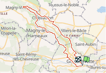

Length
19 km

Max alt
169 m

Uphill gradient
324 m
Km-Effort
23 km

Min alt
63 m

Downhill gradient
324 m
Boucle
Yes
Creation date :
2021-02-16 10:44:48.913
Updated on :
2021-02-21 07:41:10.273
5h17
Difficulty : Very difficult

FREE GPS app for hiking
 SityTrail
IGN / Geographical institutes
SityTrail Plus
The world is yours!
About
Trail Walking of 19 km to be discovered at Ile-de-France, Essonne, Gif-sur-Yvette. This trail is proposed by olivieraron.
Positioning
Country:
France
Region :
Ile-de-France
Department/Province :
Essonne
Municipality :
Gif-sur-Yvette
Location:
Unknown
Start:(Dec)
Start:(UTM)
436475 ; 5394291 (31U) N.
Comments