


SityTrail - Les Azimets

m261212
User

Length
15.9 km

Max alt
688 m

Uphill gradient
339 m
Km-Effort
20 km

Min alt
455 m

Downhill gradient
343 m
Boucle
Yes
Creation date :
2021-02-17 10:57:08.858
Updated on :
2021-02-17 11:24:10.405
2h48
Difficulty : Difficult

FREE GPS app for hiking
 SityTrail
IGN / Geographical institutes
SityTrail Plus
The world is yours!
About
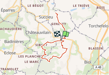
Trail Walking of 15.9 km to be discovered at Auvergne-Rhône-Alpes, Isère, Biol. This trail is proposed by m261212.
Positioning
Country:
France
Region :
Auvergne-Rhône-Alpes
Department/Province :
Isère
Municipality :
Biol
Location:
Unknown
Start:(Dec)
Start:(UTM)
684104 ; 5042147 (31T) N.
Comments