


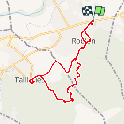
Robion - Badarel

mhetpierre
User

Length
11.2 km

Max alt
354 m

Uphill gradient
396 m
Km-Effort
16.5 km

Min alt
117 m

Downhill gradient
396 m
Boucle
Yes
Creation date :
2018-08-18 15:31:10.298
Updated on :
2018-08-18 15:31:10.298
5h46
Difficulty : Medium

FREE GPS app for hiking
 SityTrail
IGN / Geographical institutes
SityTrail Plus
The world is yours!
About
Trail Walking of 11.2 km to be discovered at Provence-Alpes-Côte d'Azur, Vaucluse, Robion. This trail is proposed by mhetpierre.
Positioning
Country:
France
Region :
Provence-Alpes-Côte d'Azur
Department/Province :
Vaucluse
Municipality :
Robion
Location:
Unknown
Start:(Dec)
Start:(UTM)
670060 ; 4857268 (31T) N.
Comments