


AZINIERES

CASSISFRAMBOISE
User
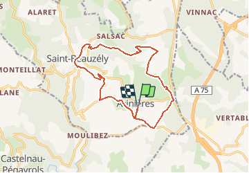

Length
15.5 km

Max alt
783 m

Uphill gradient
445 m
Km-Effort
21 km

Min alt
596 m

Downhill gradient
447 m
Boucle
Yes
Creation date :
2021-02-17 21:49:12.073
Updated on :
2021-02-17 21:49:34.238
--
Difficulty : Medium

FREE GPS app for hiking
 SityTrail
IGN / Geographical institutes
SityTrail Plus
The world is yours!
About
Trail On foot of 15.5 km to be discovered at Occitania, Aveyron, Saint-Beauzély. This trail is proposed by CASSISFRAMBOISE.
Positioning
Country:
France
Region :
Occitania
Department/Province :
Aveyron
Municipality :
Saint-Beauzély
Location:
Unknown
Start:(Dec)
Start:(UTM)
499183 ; 4888568 (31T) N.
Comments