


12557221-track-1613587191-21

Renefrt
User
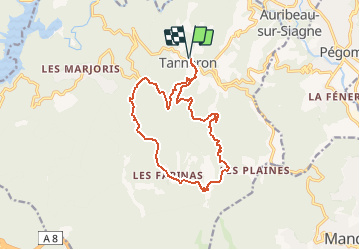

Length
15.9 km

Max alt
480 m

Uphill gradient
569 m
Km-Effort
23 km

Min alt
155 m

Downhill gradient
569 m
Boucle
Yes
Creation date :
2021-02-17 22:21:52.0
Updated on :
2021-05-09 18:56:43.398
5h20
Difficulty : Medium

FREE GPS app for hiking
 SityTrail
IGN / Geographical institutes
SityTrail Plus
The world is yours!
About
Trail Walking of 15.9 km to be discovered at Provence-Alpes-Côte d'Azur, Var, Tanneron. This trail is proposed by Renefrt.
Positioning
Country:
France
Region :
Provence-Alpes-Côte d'Azur
Department/Province :
Var
Municipality :
Tanneron
Location:
Unknown
Start:(Dec)
Start:(UTM)
328526 ; 4828652 (32T) N.
Comments