


boucle laprade 11390

Dupleix
User
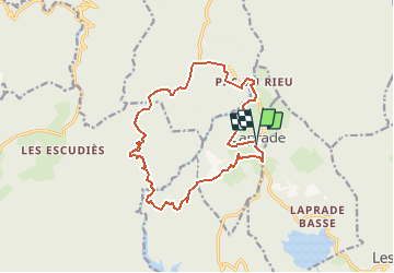

Length
16.1 km

Max alt
917 m

Uphill gradient
382 m
Km-Effort
21 km

Min alt
756 m

Downhill gradient
383 m
Boucle
Yes
Creation date :
2021-02-18 20:05:15.406
Updated on :
2021-02-18 20:06:14.686
--
Difficulty : Medium

FREE GPS app for hiking
 SityTrail
IGN / Geographical institutes
SityTrail Plus
The world is yours!
About
Trail On foot of 16.1 km to be discovered at Occitania, Aude, Laprade. This trail is proposed by Dupleix.
Positioning
Country:
France
Region :
Occitania
Department/Province :
Aude
Municipality :
Laprade
Location:
Unknown
Start:(Dec)
Start:(UTM)
439997 ; 4810185 (31T) N.
Comments