Trail Bicycle tourism Serrières-sur-Ain - Serrières --> Les rousses j1 - Photo

Serrières --> Les rousses j1

© OpenStreetMap contributors
Length
Length
105 km
Max alt
Max alt
1299 m
Uphill gradient
Uphill gradient
3156 m
Km-Effort
Km-Effort  
144 km
Min alt
Min alt
270 m
Downhill gradient
Downhill gradient
2373 m
Boucle
Boucle
No
Creation date :
2021-02-19 08:01:11.062
Updated on :
2021-02-19 08:02:52.729

(0 Reviews)

Bicycle tourism
Bicycle tourism
6h00
Difficulty : Very easy

Scan this QR Code to open this trail in the SityTrail application

FREE GPS app for hiking

Logo SityTrail SityTrail

IGN / Geographical institutes

Download SityTrail from the App Store Download SityTrail from Google Play

Logo SityTrail SityTrail World

The world is yours!

Download SityTrail from the App Store Download SityTrail from Google Play Download SityTrail on Huawei AppGallery

About

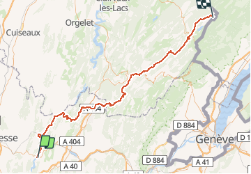
Trail Bicycle tourism of 105 km to be discovered at Auvergne-Rhône-Alpes, Ain, Serrières-sur-Ain. This trail is proposed by Nicolas Bajard.

Description

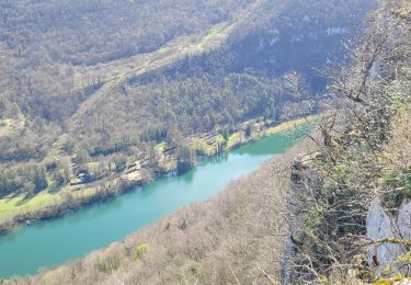
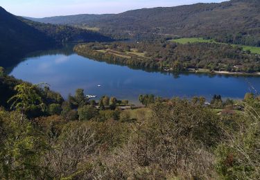
à prolonger jusqu'au lac de Joux

Elevation profile

Positioning

Country:
France
Region :
Auvergne-Rhône-Alpes
Department/Province :
Ain
Municipality :
Serrières-sur-Ain
Location:
Unknown
Start:(UTM)
689123 ; 5113747 (31T) N.

Trails nearby

Trail Walking Hautecourt-Romanèche - romaneche - Photo
Walking
loca.yves

Walking

Very difficult
Hautecourt-Romanèche, Auvergne-Rhône-Alpes, Ain, France
13 km | 19.2 km-effort
5h 20min
Yes
Trail Walking Challes-la-Montagne - challes la montagne barrage lallement la cueille sameriat - Photo
Walking
loca.yves

Walking

Easy
Challes-la-Montagne, Auvergne-Rhône-Alpes, Ain, France
10 km | 14.3 km-effort
3h 10min
Yes
Trail sport Hautecourt-Romanèche - 2023-07-08_15h37m22_Romanèche MR projet 2023 - Photo
sport
loca.yves

sport

Very easy
(1)
Hautecourt-Romanèche, Auvergne-Rhône-Alpes, Ain, France
10.8 km | 15.7 km-effort
Unknown
Yes
Trail Walking Poncin - La Cueille - Cizod  - Photo
Walking
Jackoyo

Walking

Medium
Poncin, Auvergne-Rhône-Alpes, Ain, France
8.6 km | 12.8 km-effort
1h 56min
Yes
Trail Walking Hautecourt-Romanèche - romaneche - Photo
Walking
Mer0708

Walking

Very difficult
Hautecourt-Romanèche, Auvergne-Rhône-Alpes, Ain, France
16 km | 23 km-effort
4h 5min
Yes
Trail Walking Serrières-sur-Ain - Serrières Leyssard - Photo
Walking
Jackoyo

Walking

Difficult
Serrières-sur-Ain, Auvergne-Rhône-Alpes, Ain, France
16.6 km | 26 km-effort
4h 2min
Yes
Trail Walking Peyriat - Peyriat Étables  - Photo
Walking
Jackoyo

Walking

Very easy
Peyriat, Auvergne-Rhône-Alpes, Ain, France
13.8 km | 18 km-effort
2h 32min
Yes
Trail Walking Hautecourt-Romanèche - din - Photo
Walking
loca.yves

Walking

Difficult
Hautecourt-Romanèche, Auvergne-Rhône-Alpes, Ain, France
13.7 km | 18.4 km-effort
3h 57min
Yes
Trail Mountain bike Serrières-sur-Ain - merpuis-crêtes chambod-estables-challes - Photo
Mountain bike
jujube007

Mountain bike

Difficult
Serrières-sur-Ain, Auvergne-Rhône-Alpes, Ain, France
39 km | 53 km-effort
3h 15min
Yes


Close
My subscriptions