Trail Nordic walking Fontaine-l'Évêque - activity_6295571748 - Photo

Tout seul, on va plus vite. Ensemble, on va plus loin !

© OpenStreetMap contributors
Length
Length
9.7 km
Max alt
Max alt
211 m
Uphill gradient
Uphill gradient
137 m
Km-Effort
Km-Effort  
11.5 km
Min alt
Min alt
141 m
Downhill gradient
Downhill gradient
137 m
Boucle
Boucle
Yes
Creation date :
2021-02-19 10:44:34.153
Updated on :
2021-02-19 11:29:14.466

(0 Reviews)

Nordic walking
Nordic walking
--
Difficulty : Very easy

Scan this QR Code to open this trail in the SityTrail application

FREE GPS app for hiking

Logo SityTrail SityTrail

IGN / Geographical institutes

Download SityTrail from the App Store Download SityTrail from Google Play

Logo SityTrail SityTrail Plus

The world is yours!

Download SityTrail from the App Store Download SityTrail from Google Play Download SityTrail on Huawei AppGallery

About

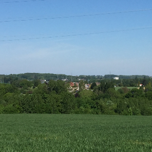
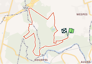
Trail Nordic walking of 9.7 km to be discovered at Wallonia, Hainaut, Fontaine-l'Évêque. This trail is proposed by Nordic Sambre (énéoSport).

Description

énéoSport - Cercle Nordic Sambre (ESNS)
Randonnée préparée Alain Damay
Point de départ/arrivée : Entrée bois de Leernes, r. Long des Bois (extrémité sud), Leernes

Elevation profile

Positioning

Country:
Belgium
Region :
Wallonia
Department/Province :
Hainaut
Municipality :
Fontaine-l'Évêque
Location:
Leernes
Start:(UTM)
593905 ; 5581461 (31U) N.


Close
My subscriptions