


peynier.j.f.marie.alain.etc

NADINE52
User
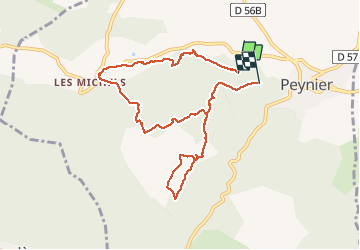

Length
9.3 km

Max alt
386 m

Uphill gradient
193 m
Km-Effort
11.9 km

Min alt
274 m

Downhill gradient
189 m
Boucle
No
Creation date :
2021-02-19 08:17:13.251
Updated on :
2021-02-19 11:11:31.165
2h27
Difficulty : Very easy

FREE GPS app for hiking
 SityTrail
IGN / Geographical institutes
SityTrail Plus
The world is yours!
About
Trail Walking of 9.3 km to be discovered at Provence-Alpes-Côte d'Azur, Bouches-du-Rhône, Peynier. This trail is proposed by NADINE52.
Photos

Positioning
Country:
France
Region :
Provence-Alpes-Côte d'Azur
Department/Province :
Bouches-du-Rhône
Municipality :
Peynier
Location:
Unknown
Start:(Dec)
Start:(UTM)
712701 ; 4813980 (31T) N.
Comments