Trail Walking Ploumoguer - Blanc sablons - Photo
 jybe
jybe

User

© OpenStreetMap contributors
Length
Length
15.5 km
Max alt
Max alt
33 m
Uphill gradient
Uphill gradient
257 m
Km-Effort
Km-Effort  
18.9 km
Min alt
Min alt
0 m
Downhill gradient
Downhill gradient
246 m
Boucle
Boucle
Yes
Creation date :
2021-01-02 10:16:32.0
Updated on :
2021-02-20 09:06:39.785

(1 Reviews)

Walking
Walking
4h31
Difficulty : Unknown

Scan this QR Code to open this trail in the SityTrail application

FREE GPS app for hiking

Logo SityTrail SityTrail

IGN / Geographical institutes

Download SityTrail from the App Store Download SityTrail from Google Play

Logo SityTrail SityTrail World

The world is yours!

Download SityTrail from the App Store Download SityTrail from Google Play Download SityTrail on Huawei AppGallery

About

Trail Walking of 15.5 km to be discovered at Brittany, Finistère, Ploumoguer. This trail is proposed by jybe.

Elevation profile

Photos

Positioning

Country:
France
Region :
Brittany
Department/Province :
Finistère
Municipality :
Ploumoguer
Location:
Unknown
Start:(UTM)
368761 ; 5362750 (30U) N.

Comments

Please log in to post a review or rate the element


Merci pour ces belles photos partagées !


Trails nearby

Trail Walking Le Conquet - 10.09.23  Le Conquet  --  Plougonvelin - Photo
Walking
donda

Walking

Very difficult
Le Conquet, Brittany, Finistère, France
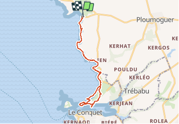
17.7 km | 21 km-effort
4h 48min
No
Trail Walking Lampaul-Plouarzel - 09.09.23  Lampaul- Plouarzel  -- Le Conquet - Photo
Walking
donda

Walking

Very difficult
Lampaul-Plouarzel, Brittany, Finistère, France
21 km | 26 km-effort
5h 49min
No
Trail Nordic walking Le Conquet - au sud du Conquet - Photo
Nordic walking
elianette

Nordic walking

Very easy
Le Conquet, Brittany, Finistère, France
42 km | 50 km-effort
22min
No
Trail Walking Lampaul-Plouarzel - Lanpaul - Lochrist - Photo
Walking
swp648

Walking

Medium
Lampaul-Plouarzel, Brittany, Finistère, France
19.8 km | 24 km-effort
5h 7min
No
Trail Walking Le Conquet - presqu'île de Kermorvan - Photo
Walking
ahelvig

Walking

Easy
(2)
Le Conquet, Brittany, Finistère, France
10 km | 11.8 km-effort
2h 54min
Yes
Trail Walking Le Conquet - Pointe de Kermovan/Fort de l'Ilette. 22/08/19. - Photo
Walking
Dervalmarc

Walking

Easy
Le Conquet, Brittany, Finistère, France
3.9 km | 4.4 km-effort
1h 53min
Yes
Trail Mountain bike Ploumoguer - Rando de Noël au nord de Brest - Ploumoguer - Photo
Mountain bike
tracegps

Mountain bike

Very difficult
Ploumoguer, Brittany, Finistère, France
85 km | 96 km-effort
7h 0min
Yes
Trail Mountain bike Ploumoguer - 73 km autour de Ploumoguer - Photo
Mountain bike
tracegps

Mountain bike

Very difficult
Ploumoguer, Brittany, Finistère, France
73 km | 87 km-effort
7h 0min
Yes
Trail Mountain bike Ploumoguer - De Ploumoguer à la pointe St-Mathieu - Photo
Mountain bike
tracegps

Mountain bike

Difficult
Ploumoguer, Brittany, Finistère, France
47 km | 55 km-effort
3h 15min
Yes


Close
My subscriptions