


Les Avants de st Mathieu

kephas
User
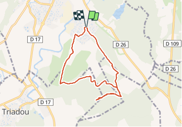

Length
8.9 km

Max alt
149 m

Uphill gradient
118 m
Km-Effort
10.5 km

Min alt
102 m

Downhill gradient
120 m
Boucle
Yes
Creation date :
2014-12-10 00:00:00.0
Updated on :
2014-12-10 00:00:00.0
127h46
Difficulty : Unknown

FREE GPS app for hiking
 SityTrail
IGN / Geographical institutes
SityTrail Plus
The world is yours!
About
Trail Walking of 8.9 km to be discovered at Occitania, Hérault, Saint-Mathieu-de-Tréviers. This trail is proposed by kephas.
Description
Balade tranquille avec beaux points de vue sur le Pic st Loup
Positioning
Country:
France
Region :
Occitania
Department/Province :
Hérault
Municipality :
Saint-Mathieu-de-Tréviers
Location:
Unknown
Start:(Dec)
Start:(UTM)
570696 ; 4845648 (31T) N.
Comments