


Le Capet

mitch1952
User
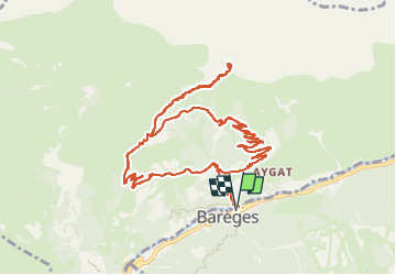

Length
14.9 km

Max alt
2300 m

Uphill gradient
1125 m
Km-Effort
30 km

Min alt
1221 m

Downhill gradient
1127 m
Boucle
Yes
Creation date :
2021-02-20 16:26:46.926
Updated on :
2022-06-08 09:26:38.618
6h48
Difficulty : Very difficult

FREE GPS app for hiking
 SityTrail
IGN / Geographical institutes
SityTrail Plus
The world is yours!
About
Trail Walking of 14.9 km to be discovered at Occitania, Hautespyrenees, Barèges. This trail is proposed by mitch1952.
Positioning
Country:
France
Region :
Occitania
Department/Province :
Hautespyrenees
Municipality :
Barèges
Location:
Unknown
Start:(Dec)
Start:(UTM)
260254 ; 4753552 (31T) N.
Comments