


Pène de Souquette

mitch1952
User
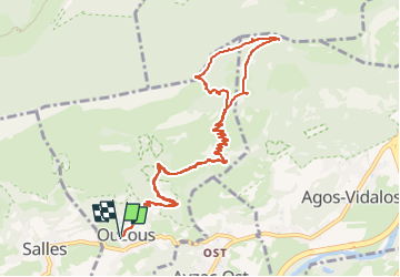

Length
13.2 km

Max alt
1424 m

Uphill gradient
882 m
Km-Effort
25 km

Min alt
578 m

Downhill gradient
882 m
Boucle
Yes
Creation date :
2021-02-20 16:57:06.15
Updated on :
2022-06-08 09:37:01.547
5h40
Difficulty : Very difficult

FREE GPS app for hiking
 SityTrail
IGN / Geographical institutes
SityTrail Plus
The world is yours!
About
Trail Walking of 13.2 km to be discovered at Occitania, Hautespyrenees, Ouzous. This trail is proposed by mitch1952.
Positioning
Country:
France
Region :
Occitania
Department/Province :
Hautespyrenees
Municipality :
Ouzous
Location:
Unknown
Start:(Dec)
Start:(UTM)
735630 ; 4768176 (30T) N.
Comments