


St léger

adamfv
User
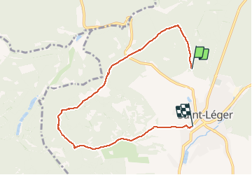

Length
6.8 km

Max alt
350 m

Uphill gradient
97 m
Km-Effort
8.3 km

Min alt
259 m

Downhill gradient
137 m
Boucle
No
Creation date :
2021-02-21 10:05:52.0
Updated on :
2021-02-21 11:42:38.416
1h34
Difficulty : Unknown

FREE GPS app for hiking
 SityTrail
IGN / Geographical institutes
SityTrail Plus
The world is yours!
About
Trail Walking of 6.8 km to be discovered at Wallonia, Luxembourg, Saint-Léger. This trail is proposed by adamfv.
Positioning
Country:
Belgium
Region :
Wallonia
Department/Province :
Luxembourg
Municipality :
Saint-Léger
Location:
Saint-Léger
Start:(Dec)
Start:(UTM)
691662 ; 5499839 (31U) N.
Comments