


03-1-2021 du 21.03.2021

bene_dictus77
User
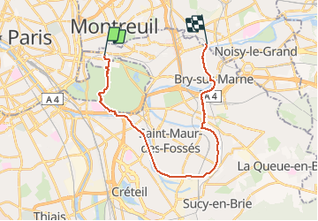

Length
23 km

Max alt
69 m

Uphill gradient
151 m
Km-Effort
25 km

Min alt
29 m

Downhill gradient
168 m
Boucle
No
Creation date :
2021-02-21 09:22:35.551
Updated on :
2021-02-21 15:14:13.296
5h49
Difficulty : Very easy

FREE GPS app for hiking
 SityTrail
IGN / Geographical institutes
SityTrail Plus
The world is yours!
About
Trail Walking of 23 km to be discovered at Ile-de-France, Val-de-Marne, Vincennes. This trail is proposed by bene_dictus77.
Description
De Vincennes à Neuilly Plaisance par boucle de Saint Maur
Positioning
Country:
France
Region :
Ile-de-France
Department/Province :
Val-de-Marne
Municipality :
Vincennes
Location:
Unknown
Start:(Dec)
Start:(UTM)
458499 ; 5410606 (31U) N.
Comments