


deurne

jjspenle
User
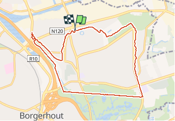

Length
9.6 km

Max alt
14 m

Uphill gradient
59 m
Km-Effort
10.4 km

Min alt
-5 m

Downhill gradient
57 m
Boucle
Yes
Creation date :
2021-02-21 13:15:09.862
Updated on :
2021-02-21 15:20:34.282
1h49
Difficulty : Very easy

FREE GPS app for hiking
 SityTrail
IGN / Geographical institutes
SityTrail Plus
The world is yours!
About
Trail Walking of 9.6 km to be discovered at Flanders, Antwerp, Antwerp. This trail is proposed by jjspenle.
Positioning
Country:
Belgium
Region :
Flanders
Department/Province :
Antwerp
Municipality :
Antwerp
Location:
Deurne
Start:(Dec)
Start:(UTM)
601800 ; 5676609 (31U) N.
Comments