Trail Walking Rebecq - 2021-02-21 13:21:36 - Photo

2021-02-21 13:21:36

© OpenStreetMap contributors
Length
Length
11.9 km
Max alt
Max alt
87 m
Uphill gradient
Uphill gradient
145 m
Km-Effort
Km-Effort  
13.8 km
Min alt
Min alt
44 m
Downhill gradient
Downhill gradient
146 m
Boucle
Boucle
Yes
Creation date :
2021-02-21 16:40:26.936
Updated on :
2021-04-15 13:22:37.436

(0 Reviews)

Walking
Walking
3h08
Difficulty : Difficult

Scan this QR Code to open this trail in the SityTrail application

FREE GPS app for hiking

Logo SityTrail SityTrail

IGN / Geographical institutes

Download SityTrail from the App Store Download SityTrail from Google Play

Logo SityTrail SityTrail Plus

The world is yours!

Download SityTrail from the App Store Download SityTrail from Google Play Download SityTrail on Huawei AppGallery

About

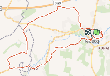
Trail Walking of 11.9 km to be discovered at Wallonia, Walloon Brabant, Rebecq. This trail is proposed by Luberon1963.

Description

Boucle à partir du centre de Rebecq (départ parking près de la maison communale - Moulins d'Aremberg).
Trajet empruntant principalement des routes de campagne goudronnées, comprenant quelques sentiers et chemins de terre.
Petit passage sur le territoire de Steenkerque (côté "Ferme des prés")

Elevation profile

Points of interest

Point of interest Rebecq - Vergers du Paradis - Photo
Luberon1963
Point of interest Braine-le-Comte - Gîte des prés (ferme des prés) - Photo
Luberon1963
Point of interest Rebecq - Chapelle Saint-Roch - Photo
Luberon1963
Point of interest Rebecq - Moulins d'Aremberg - Photo
Luberon1963

Positioning

Country:
Belgium
Region :
Wallonia
Department/Province :
Walloon Brabant
Municipality :
Rebecq
Location:
Rebecq-Rognon
Start:(UTM)
580109 ; 5613056 (31U) N.


Close
My subscriptions