


Boucle Zermat - Z'mut

seghth
User
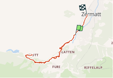

Length
8.3 km

Max alt
1960 m

Uphill gradient
418 m
Km-Effort
13.9 km

Min alt
1616 m

Downhill gradient
422 m
Boucle
No
Creation date :
2021-02-22 09:19:25.38
Updated on :
2021-02-22 12:46:27.634
2h30
Difficulty : Very easy

FREE GPS app for hiking
 SityTrail
IGN / Geographical institutes
SityTrail Plus
The world is yours!
About
Trail Walking of 8.3 km to be discovered at Valais/Wallis, Visp, Zermatt. This trail is proposed by seghth.
Description
Via slumzee, avec raquettes
Positioning
Country:
Switzerland
Region :
Valais/Wallis
Department/Province :
Visp
Municipality :
Zermatt
Location:
Unknown
Start:(Dec)
Start:(UTM)
402510 ; 5096394 (32T) N.
Comments