


selestat ried

jcschubnel
User
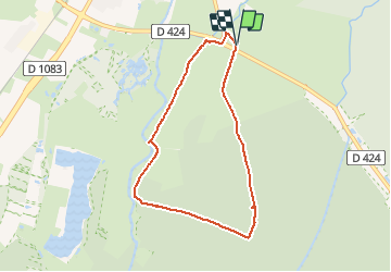

Length
6.8 km

Max alt
185 m

Uphill gradient
61 m
Km-Effort
7.7 km

Min alt
163 m

Downhill gradient
67 m
Boucle
Yes
Creation date :
2021-02-22 12:47:09.237
Updated on :
2021-02-22 16:13:00.716
2h00
Difficulty : Very easy

FREE GPS app for hiking
 SityTrail
IGN / Geographical institutes
SityTrail Plus
The world is yours!
About
Trail Walking of 6.8 km to be discovered at Grand Est, Bas-Rhin, Sélestat. This trail is proposed by jcschubnel.
Positioning
Country:
France
Region :
Grand Est
Department/Province :
Bas-Rhin
Municipality :
Sélestat
Location:
Unknown
Start:(Dec)
Start:(UTM)
385799 ; 5344824 (32U) N.
Comments