


croix des travers

BELLETGE
User
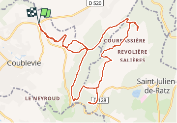

Length
13.8 km

Max alt
702 m

Uphill gradient
375 m
Km-Effort
18.7 km

Min alt
407 m

Downhill gradient
372 m
Boucle
Yes
Creation date :
2021-02-22 12:21:59.227
Updated on :
2021-02-22 17:16:21.569
3h24
Difficulty : Very easy

FREE GPS app for hiking
 SityTrail
IGN / Geographical institutes
SityTrail Plus
The world is yours!
About
Trail Walking of 13.8 km to be discovered at Auvergne-Rhône-Alpes, Isère, Coublevie. This trail is proposed by BELLETGE.
Positioning
Country:
France
Region :
Auvergne-Rhône-Alpes
Department/Province :
Isère
Municipality :
Coublevie
Location:
Unknown
Start:(Dec)
Start:(UTM)
705286 ; 5026888 (31T) N.
Comments