


01 Bellarge sur Valserine

trietsch
User
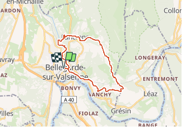

Length
13 km

Max alt
769 m

Uphill gradient
503 m
Km-Effort
19.7 km

Min alt
342 m

Downhill gradient
503 m
Boucle
Yes
Creation date :
2021-02-22 17:44:37.8
Updated on :
2021-02-22 17:46:53.572
4h28
Difficulty : Very difficult

FREE GPS app for hiking
 SityTrail
IGN / Geographical institutes
SityTrail Plus
The world is yours!
About
Trail Walking of 13 km to be discovered at Auvergne-Rhône-Alpes, Ain, Valserhône. This trail is proposed by trietsch.
Description
Départ de la Gare
Positioning
Country:
France
Region :
Auvergne-Rhône-Alpes
Department/Province :
Ain
Municipality :
Valserhône
Location:
Bellegarde-sur-Valserine
Start:(Dec)
Start:(UTM)
718320 ; 5110178 (31T) N.
Comments