


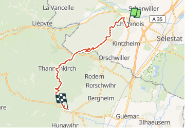
GR5 J12 Châtenois Ribeauvillé 20 400m +807m

DanielROLLET
User

Length
20 km

Max alt
726 m

Uphill gradient
807 m
Km-Effort
31 km

Min alt
188 m

Downhill gradient
743 m
Boucle
No
Creation date :
2021-02-22 19:04:48.633
Updated on :
2021-04-30 14:28:59.57
7h02
Difficulty : Very difficult

FREE GPS app for hiking
 SityTrail
IGN / Geographical institutes
SityTrail Plus
The world is yours!
About
Trail Walking of 20 km to be discovered at Grand Est, Bas-Rhin, Châtenois. This trail is proposed by DanielROLLET.
Positioning
Country:
France
Region :
Grand Est
Department/Province :
Bas-Rhin
Municipality :
Châtenois
Location:
Unknown
Start:(Dec)
Start:(UTM)
381221 ; 5347726 (32U) N.
Comments