


Ski20210223

Valery01
User
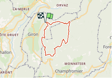

Length
11.9 km

Max alt
1217 m

Uphill gradient
255 m
Km-Effort
15.3 km

Min alt
1136 m

Downhill gradient
256 m
Boucle
Yes
Creation date :
2021-02-23 08:55:28.0
Updated on :
2021-02-24 10:21:52.79
2h46
Difficulty : Unknown

FREE GPS app for hiking
 SityTrail
IGN / Geographical institutes
SityTrail Plus
The world is yours!
About
Trail Cross-country skiing of 11.9 km to be discovered at Auvergne-Rhône-Alpes, Ain, Giron. This trail is proposed by Valery01.
Positioning
Country:
France
Region :
Auvergne-Rhône-Alpes
Department/Province :
Ain
Municipality :
Giron
Location:
Unknown
Start:(Dec)
Start:(UTM)
714900 ; 5123761 (31T) N.
Comments