


laxou avec nanard

claudel
User
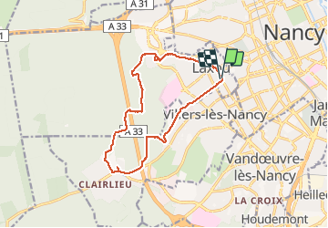

Length
13.4 km

Max alt
370 m

Uphill gradient
213 m
Km-Effort
16.2 km

Min alt
215 m

Downhill gradient
213 m
Boucle
Yes
Creation date :
2021-02-24 08:13:11.919
Updated on :
2021-02-24 12:24:37.038
4h09
Difficulty : Very easy

FREE GPS app for hiking
 SityTrail
IGN / Geographical institutes
SityTrail Plus
The world is yours!
About
Trail Walking of 13.4 km to be discovered at Grand Est, Meurthe-et-Moselle, Laxou. This trail is proposed by claudel.
Positioning
Country:
France
Region :
Grand Est
Department/Province :
Meurthe-et-Moselle
Municipality :
Laxou
Location:
Unknown
Start:(Dec)
Start:(UTM)
290675 ; 5396022 (32U) N.
Comments