


canal de carpentras

aupi
User
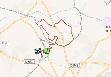

Length
9.2 km

Max alt
102 m

Uphill gradient
60 m
Km-Effort
10 km

Min alt
79 m

Downhill gradient
60 m
Boucle
Yes
Creation date :
2021-02-24 12:32:01.903
Updated on :
2021-02-24 15:19:39.044
2h32
Difficulty : Very easy

FREE GPS app for hiking
 SityTrail
IGN / Geographical institutes
SityTrail Plus
The world is yours!
About
Trail Walking of 9.2 km to be discovered at Provence-Alpes-Côte d'Azur, Vaucluse, Loriol-du-Comtat. This trail is proposed by aupi.
Positioning
Country:
France
Region :
Provence-Alpes-Côte d'Azur
Department/Province :
Vaucluse
Municipality :
Loriol-du-Comtat
Location:
Unknown
Start:(Dec)
Start:(UTM)
662495 ; 4881665 (31T) N.
Comments