


dargoire 7.8.a g1 d33 24 02 21

jtraverse
User
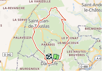

Length
7.8 km

Max alt
350 m

Uphill gradient
179 m
Km-Effort
10.2 km

Min alt
235 m

Downhill gradient
184 m
Boucle
Yes
Creation date :
2021-02-24 12:51:01.077
Updated on :
2021-02-24 15:22:01.496
2h30
Difficulty : Very easy

FREE GPS app for hiking
 SityTrail
IGN / Geographical institutes
SityTrail Plus
The world is yours!
About
Trail Walking of 7.8 km to be discovered at Auvergne-Rhône-Alpes, Loire, Dargoire. This trail is proposed by jtraverse.
Positioning
Country:
France
Region :
Auvergne-Rhône-Alpes
Department/Province :
Loire
Municipality :
Dargoire
Location:
Unknown
Start:(Dec)
Start:(UTM)
630344 ; 5046583 (31T) N.
Comments