


Marcenod

psesjs
User
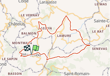

Length
20 km

Max alt
918 m

Uphill gradient
657 m
Km-Effort
29 km

Min alt
667 m

Downhill gradient
659 m
Boucle
Yes
Creation date :
2021-02-24 08:22:02.237
Updated on :
2021-02-24 15:23:20.297
4h50
Difficulty : Very easy

FREE GPS app for hiking
 SityTrail
IGN / Geographical institutes
SityTrail Plus
The world is yours!
About
Trail Walking of 20 km to be discovered at Auvergne-Rhône-Alpes, Loire, Marcenod. This trail is proposed by psesjs.
Description
Chemin des croix
Photos


Positioning
Country:
France
Region :
Auvergne-Rhône-Alpes
Department/Province :
Loire
Municipality :
Marcenod
Location:
Unknown
Start:(Dec)
Start:(UTM)
615674 ; 5047540 (31T) N.
Comments