


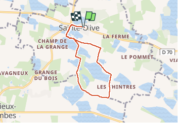
01 - SAINTE-OLIVE

AndreLACOMBE
User

Length
6.6 km

Max alt
299 m

Uphill gradient
37 m
Km-Effort
7.1 km

Min alt
288 m

Downhill gradient
36 m
Boucle
Yes
Creation date :
2021-02-24 13:17:27.76
Updated on :
2021-02-24 15:47:47.233
2h29
Difficulty : Very easy

FREE GPS app for hiking
 SityTrail
IGN / Geographical institutes
SityTrail Plus
The world is yours!
About
Trail Walking of 6.6 km to be discovered at Auvergne-Rhône-Alpes, Ain, Sainte-Olive. This trail is proposed by AndreLACOMBE.
Description
Circuit des étangs de Dombes.
Parking près de la mairie.
Positioning
Country:
France
Region :
Auvergne-Rhône-Alpes
Department/Province :
Ain
Municipality :
Sainte-Olive
Location:
Unknown
Start:(Dec)
Start:(UTM)
649646 ; 5097962 (31T) N.
Comments